Locating Underground Assets
By NASSCO Technical Advisory Council Member Kaleel Rahaim, CIPP Consulting, LLC
As municipalities and other agencies embrace the concept of asset management for their underground infrastructure, locating and identifying those assets become more important. In the past, the options for locating and identifying underground assets were a challenge. Typical resources were either scarce or unreliable, and the training offered engineers in locating and identifying those assets was even scarier. With technological innovations, better training, and more wellestablished guidelines now available, the identification of underground utility locations becomes less of a mystery.
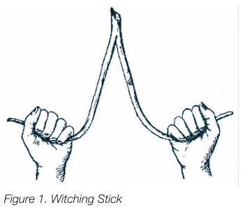
Early in our history of attempting to locate anything of value underground, witching sticks were used. Depending on the quest, a branch of a particular species of tree was used (Figure 1.). Believe it or not, even today some still swear by the accuracy of this method. The more sophisticated methods now available, however, give all concerned a better sense of certainty in the results.
In attempting a records search, engineers were at times frustrated at the lack of records and did not have confidence in the records that were available.
Records available ranged from hand drawn records on napkins to sophisticated CAD drawings. Word of mouth from current and past employees of a municipality, an engineering firm, or even a local citizen were at times the only source of information about the location of an asset. Luckily, GPS capabilities and state of the science geophysical tools available today allow mapping of utilities to gain a higher level of certainty.
One of the earliest methods of near surface geophysical tools developed uses an electromagnetic field (Figure 2.)

These are generally radio frequency electromagnetic types commonly known as pipe and cable locators (PCLs). The handheld equipment consists of a transmitter and a receiver. An operator “sweeps” the area of interest to locate and find the approximate depth of the facility.
An operator can be easily trained to use this equipment, and experience in using it results in more confident output. Since an electromagnetic wave is used in this equipment, the underground pipe or cable sought must be made of a conductive material.
This equipment cannot detect plastic pipes unless a tracer wire has been installed with the pipe. Detection of the facility is by audible means, and local electromagnetic interference may impede the accuracy of this method.
Another method for detecting underground facilities is the use of ground penetrating radar (GPR). This compact, portable unit is easy to transport and manipulate in small areas (Figure 3.)
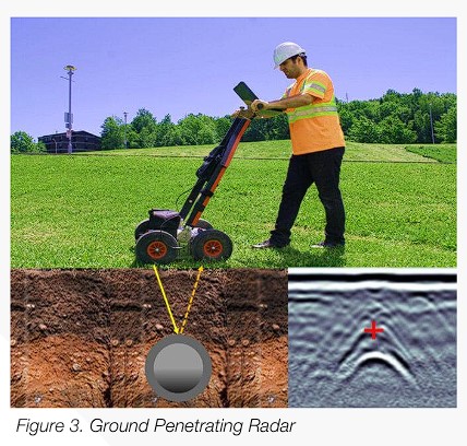
Operators trained in using this equipment use the display screen on the equipment to identify the location of the facility. The equipment may be a one man push apparatus, as shown, or a multichannel array (MCGPR) pulled or pushed with motorized equipment. The apparatus may be equipped with a GPS to provide a location for mapping. The suitability of using this method depends on soil conditions; heavy, clay soils are not ideal soil conditions for using this method, while loose, sandy soils are ideal. This method can detect metal, plastic, and clay pipes and cables of different compositions. Using the MCGPR can also detect voids such as underground vaults.
Other methods used may be frequency domain electromagnetic detectors (FDEM), Seismic methods (elastic waves), or electrical resistivity methods. More options are becoming available with the advancement of science.
Engineers have guidance in investigating underground assets in two American Society of Civil Engineers (ASCE) Standards, ASCE 38-22 and ASCE 75-22. ASCE 38-22 addresses:
- Investigative practices;
- Conveyance of utility data;
- Respective roles in communicating and deciding the scope of work on a utility project;
- Definition of utility quality levels;
- Guidance in preparing reports, and much more
With these guidance documents, ASCE defined Subsurface Utility Engineering (SUE) as an engineering practice in an ASCE publication entitled “Subsurface Utility Engineering for Municipalities” 2019. This document as well as the ASCE Standards may be obtained from the American Society of Civil Engineers.
From witching sticks to multifaceted electronic equipment and defining a new discipline of engineering, locating and identifying underground facilities have become more exact. With this wealth of available equipment and knowledge, municipalities and other governmental agencies now have a wealth of resources to identify and manage their underground assets more precisely than before
TECH TIPS IS A BI-MONTHLY ARTICLE ON TRENDS, BEST PRACTICES AND INDUSTRY ADVICE FROM NASSCO’S TRENCHLESS TECHNOLOGY MEMBERSHIP PROFESSIONALS
Follow us on social media or visit NASSCO.org